Study Area |
Garee, Khan, et al. Water 9.1 (2017): 17 |
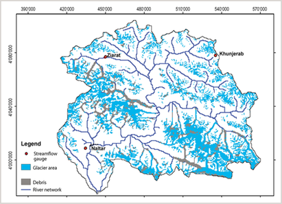
River flow gauging station Dainyor Bridge
Latitude 35.5_37N
Longitude 74_76 E
Elevation of gauging station 1450 m
Drainage area 13,733 km2
Glacier-covered area 4688 km2
Glacier cover percentage 34 %
Mean elevation (computed from 4631 m
ASTER GDEM)
Area above 5000 m 32.5 %
No. of meteorological stations 3 (Installed by WAPDA)
Khunjerab Ziarat Naltar
4730 m 3669 m 2858 m
|
|
